Amazonas - Geography Lesson
See just this Post & Comments / 0 Comments so far / Post a Comment / Home
Up, Down, Thread Ahead: Amazonas - O Rumo Perdido, Thread Back: Amazonas - Pogo.
I have gone about today, to and fro in the internet, walking up and down in it (as it were), collecting maps and trying to build a little moral dyke or levee of facts against the flow of yesterday's moral frisson - that maybe this drought is at least partly a hoax played out upon myself by myself. And I have not found Job yet, though I did find something good:
http://www.ilike2learn.com
which is a little geographical learning centre and quite fun.
As I was looking for Rio Parana de Manaquiri, which I have not found yet either, but which runs by the town of Manaquiri, so it won't be long until I do find it - I realized that the internet is a moving target. Pages come and go like the leaves in their seasons. Nothing makes a surfer quit a website faster than finding one or two links that lead to 404's, and when the surfers leave so also goes the click-currency that came with them, the sweet revenue jam, and soon the whole site disappears. The thing seems to reproduce asexually by the same mechanism as those ancient plants, the Bryophytes - a process known as "death from behind". This is a good thing because it means that the internet is not a self-replicating entity. As pages wither and die and fall off, the links to them in other parts of the web must be either abandoned or renewed. They can be abandoned by an automaton but they cannot be renewed by one! Not yet certainly, and not until links somehow come to embody intent. Here is a link to a site called 'Joe_Btfsplk'; What shall I renew it with? What did the person who put it here have in mind? What did he or she intend? Hard enough for a human curator nevermind a robot.
Eventually I did so find some excellent and comprehensive maps, vintage 2001, provided free for the downloading by the Brasilian government:
http://www.dner.gov.br/rodovias/mapas/
Unfortunately the text in them is not text and cannot be searched (or I would have found Manaquiri before now) but they are superior I think to the arrogant but lame Geographical Information Systems (GIS) which I found. Try this one f'rinstance:
http://www.amazongis.org/maps/viewer/normal.html?ServiceName=ci)
I am tempted to say arrogant 'left-lib' GISs, but I will stifle that one for now. Have a look at both and judge for yourself. Also unfortunately, the government maps are wrapped up in Adobe .pdf files which I have not been able to crack yet, so I cannot post the images themselves directly to this site.
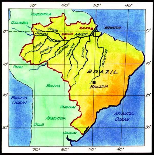
Ok, here is a quick layout of it with major tributaries:

Some obvious facts may jump out at you more quickly than they did to me - it is simply HUMONGOUS, look at it! Spanning numerous international boundaries as well as numerous lines of longitude and latitude. Is it not the biggest thing in the world, at all, at all, at all? Bigger even than the beast in Rudyard Kipling's story The Butterfly that Stamped? I would credit Kipling (btw) for keeping this notion in the culture long enough to be picked up by the Chaos Theory crowd - but that is another story ...
As I started with Job, so I will end with Matthew:
Take therefore no thought for the morrow: for the morrow shall take thought for the things of itself. Sufficient unto the day is the evil thereof.
Although it is exactly tomorrow that I am thinking of as I break off. Esteja bem. Até amanha.
Down.
I have gone about today, to and fro in the internet, walking up and down in it (as it were), collecting maps and trying to build a little moral dyke or levee of facts against the flow of yesterday's moral frisson - that maybe this drought is at least partly a hoax played out upon myself by myself. And I have not found Job yet, though I did find something good:
http://www.ilike2learn.com
which is a little geographical learning centre and quite fun.
As I was looking for Rio Parana de Manaquiri, which I have not found yet either, but which runs by the town of Manaquiri, so it won't be long until I do find it - I realized that the internet is a moving target. Pages come and go like the leaves in their seasons. Nothing makes a surfer quit a website faster than finding one or two links that lead to 404's, and when the surfers leave so also goes the click-currency that came with them, the sweet revenue jam, and soon the whole site disappears. The thing seems to reproduce asexually by the same mechanism as those ancient plants, the Bryophytes - a process known as "death from behind". This is a good thing because it means that the internet is not a self-replicating entity. As pages wither and die and fall off, the links to them in other parts of the web must be either abandoned or renewed. They can be abandoned by an automaton but they cannot be renewed by one! Not yet certainly, and not until links somehow come to embody intent. Here is a link to a site called 'Joe_Btfsplk'; What shall I renew it with? What did the person who put it here have in mind? What did he or she intend? Hard enough for a human curator nevermind a robot.
Eventually I did so find some excellent and comprehensive maps, vintage 2001, provided free for the downloading by the Brasilian government:
http://www.dner.gov.br/rodovias/mapas/
Unfortunately the text in them is not text and cannot be searched (or I would have found Manaquiri before now) but they are superior I think to the arrogant but lame Geographical Information Systems (GIS) which I found. Try this one f'rinstance:
http://www.amazongis.org/maps/viewer/normal.html?ServiceName=ci)
I am tempted to say arrogant 'left-lib' GISs, but I will stifle that one for now. Have a look at both and judge for yourself. Also unfortunately, the government maps are wrapped up in Adobe .pdf files which I have not been able to crack yet, so I cannot post the images themselves directly to this site.
Ok, here is a quick layout of it with major tributaries:
Some obvious facts may jump out at you more quickly than they did to me - it is simply HUMONGOUS, look at it! Spanning numerous international boundaries as well as numerous lines of longitude and latitude. Is it not the biggest thing in the world, at all, at all, at all? Bigger even than the beast in Rudyard Kipling's story The Butterfly that Stamped? I would credit Kipling (btw) for keeping this notion in the culture long enough to be picked up by the Chaos Theory crowd - but that is another story ...
As I started with Job, so I will end with Matthew:
Take therefore no thought for the morrow: for the morrow shall take thought for the things of itself. Sufficient unto the day is the evil thereof.
Although it is exactly tomorrow that I am thinking of as I break off. Esteja bem. Até amanha.
Down.